Machame Route
BASE CAMP MOUNTAIN CLIMBING IN TANZANIA
MACHAME ROUTE
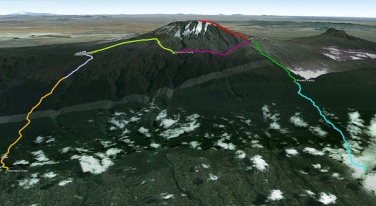
The Machame route is described here. The route is typically done on a six or seven day hike.
The campsites and gates (with corresponding elevations) are as follows:
Machame Gate (start of trek) 5,718 feet (1,743 m)
Machame 9,927 feet (3,026 m)
Shira 12,355 feet (3,766 m)
Barranco 13,066 feet (3,983 m)
Karanga (optional camp, used by 7-day climbers)
Barafu (high camp before summit) 15,239 feet (4,645 m)
Mweka (descent) 10,204 feet (3,110 m)
Mweka Gate (end of trek) 5,423 feet (1,653 m)
One benefit of the Machame route is its quick rise to relatively high elevations (~10,000 feet (3,000 m)), and a short ascent to the Lava Tower site (~15,000 feet (4,600 m)) before descending back to Barranco Camp (~12,700 feet (3,900 m)) on the same day. This follows the climber’s adage “climb high, sleep low”, and helps altitude acclimation. The initial steep ascent also helps trekkers acclimatise better.
The Machame route starts from Machame Gate and travels upwards through the montane rainforest, characterized by dense vegetation, a muddy trail, and short sections of steep climbs. The first campsite, Machame Camp, is right after the dense tree cover in an area with lower but still thick bushlands.
The second day continues through increasingly sparse trees and bushes into moorlands. The day finishes with Shira Camp, which is on a small plateau in the high moorlands, and features views of Kibo in the northwest and Mount Meru towards the east. White necked ravens can be seen throughout the day. There is also a set of small caves a short walk from the campsite known as the Shira Caves.
Garden of the Senecios, with part of Kibo in the background.
High camp at Barafu. GPS showing elevation (15287 feet).
The third day starts in the moorlands and moves into alpine desert, with fewer trees and more rocks. The highest point is the base of the Lava Tower, after which the trail descends into the Barranco Valley. More vegetation is present in this zone, especially the area just before the campsite. This area is called the “Garden of the Senecios”, which features many of the huge senecio plants. Shorter lobelia plants are also present.
The fourth day starts with the ascent of the Barranco Wall, which is considered a scramble in climbing terms. The trail continues with many up and down sections across small streams and rivulets and finally crosses the Karanga River to the Karanga campsite.
The fifth day follows the path up and across a rocky zone, finishing at the high camp Barafu. Very little vegetation can be found on the inhospitable terrain. A field of sedimentary rocks litters the ground. (Note – the six day trek omits the Karanga campsite, and trekkers continue directly to Barafu on the same day.)
The summit is usually attempted on the very early morning of the sixth day (around midnight). Barafu is also used as a summit campsite for the Umbwe route. Trekkers typically take somewhere between five and seven hours to ascend, using headlamps and cold weather gear. Making the ascent on a full moon or shortly thereafter can make the headtorch unnecessary. The first milestone, generally reached shortly after dawn, is Stella Point (18,652 feet (5,685 m)), which is on the crater rim. Following Stella Point, the trail continues for another 60 minutes to Uhuru Peak, the summit.
The descent back to Barafu takes roughly four hours. Some trekkers scree slide down the slope, which entails skidding/running down the loose gravel at medium speed. From Barafu, trekkers typically take a short break, and continue downwards through the alpine desert and ensuing moorlands to Mweka Camp.
The seventh and final day has trekkers continue through the montane forest to Mweka Gate. Troops of black-and-white colobus monkeys can often be seen in the dense growth.


